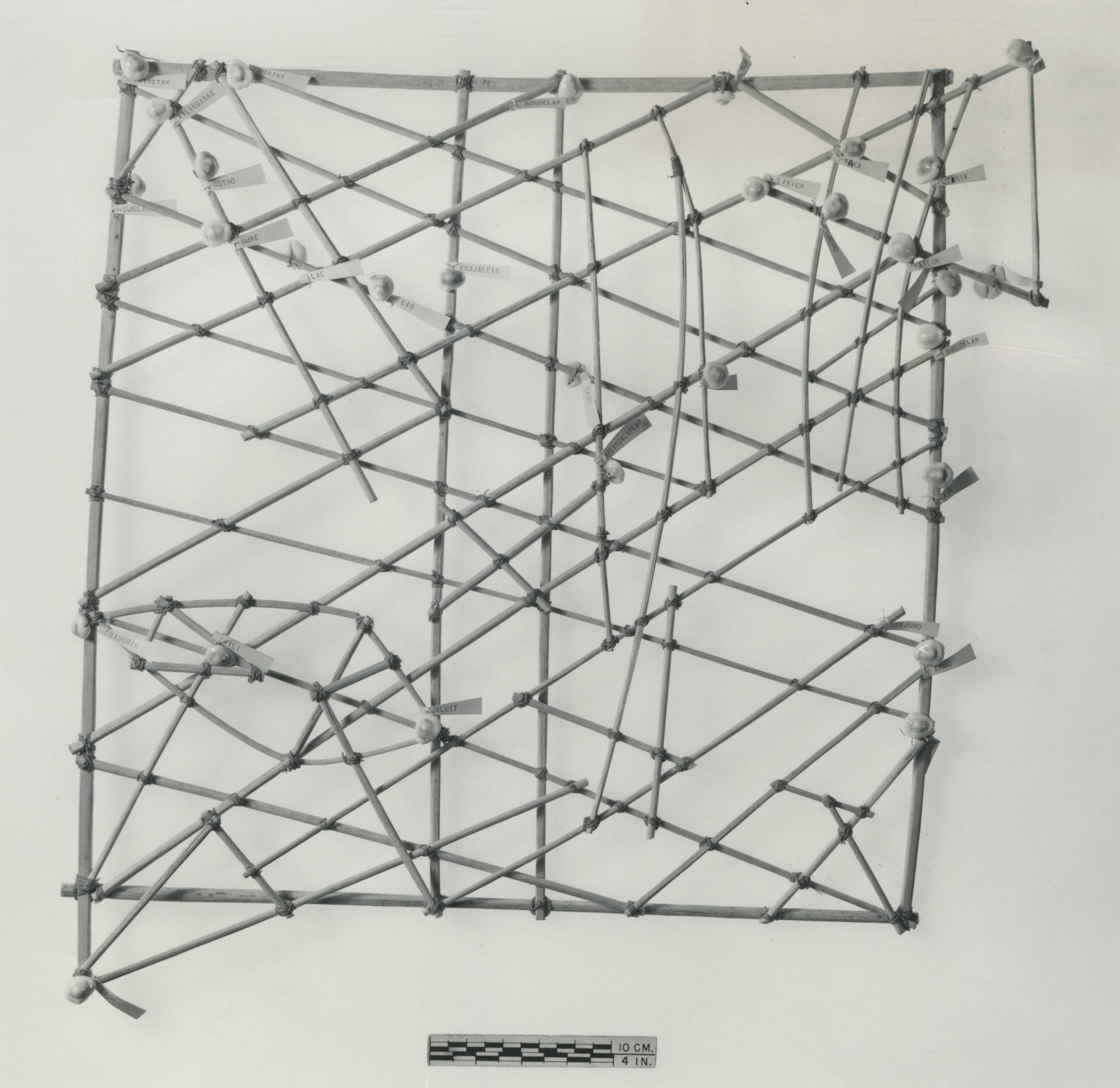
Stick Chart
Marshall Islands, twentieth century, wood, snail shell, plant fiber cord
Courtesy of the National Museum of Natural History, Smithsonian Institution
Marshall Islands, twentieth century, wood, snail shell, plant fiber cord
Courtesy of the National Museum of Natural History, Smithsonian Institution
Earth is the only planet yet found where wind blows over open water. The bright light and radiant heat of our sun excites the atmospheric gases, and this thermal shift incites kinetic motion in the air that hovers over the watery deep, causing warm air to rise while the cold sinks, which we perceive as wind. As the wind passes over the vast expanses of water that sheath our mottled orb—70 percent of which is ocean—some of the wind’s energy is imparted to the water, and as this energy moves, it becomes visible as waves.
If we look down on foamy waves from a departing flight, we may be tempted to imagine that the water we see is moving horizontally, but it is not. If you stand at the foot of your bed holding the edges of a flat bedsheet in both hands and in a single motion move your hands up and then down, you will induce a wave in the bedsheet—yet neither the edges of the sheet you held nor the sheet itself ever travel forward. It is the same at sea: molecules of water whipped by a squall off the shore of Japan do not themselves travel to Papua New Guinea but instead remain in the vicinity of Tokyo where they were first tickled, while the energy imparted to that oceanic water begins an oscillation of locally jostling molecules and, depending on the wind’s duration and strength, this energy may travel unimpeded for thousands of miles.
When wind blows with great force over vast distances, as we find in storms at sea, the distance between waves becomes longer and the energy driving the wave greater, such that many days after a storm has shifted or abated, these waves will continue to propagate as a particular type of wave we call swell. While waves are a local phenomenon, swell travels beyond the wind system that birthed it. Peering down from a transatlantic cabin, we can observe swell marching across the sea in broad lines with big gaps between crests, passing through or under everything in its path, including other swell, unperturbed even as it is buffeted by storms. Over time, old swell slowly dissipates, shifting toward greater wavelengths and fanning out as it drives across the oceanic expanse until it reaches a faraway shore and breaks.
To continental dwellers, adapted to terra firma, the ocean is a chaotic melee. But for the navigators of the Marshall Islands, patterns in the sea were as familiar as the faces of friends. Across the islands and atolls, swell arrives in dependable, rolling rows. Trained navigators could deduce the location of land simply by observing the behavior of water around it. When the swell breaks around an island, predictable effects occur. Reflected waves bounce back, calmer waters and the absence of swell lurk in shadows behind islands, and complex patterns emerge as swell pinballs around thirty-four sandy spits. This might sound simple, but it is in practice a fiendishly exacting skill. Experienced navigators discerned with ease where smaller waves rode on top of bigger waves. They read through temporary surface waves to the underlying swell, interpreting the influence of distant islands, sensing and mapping the location of land in real time.
Navigation was a source of power, the lever without which resources could not be moved among the watery kingdoms of the Pacific. For thousands of years this knowledge remained a closely guarded secret, with elder navigators training a select few initiates in the arcanum. When one Captain Winkler of the German Navy encountered Marshall Island navigators in the 1890s, he recorded that they considered it “strongly and religiously forbidden to divulge anything concerning this art.” Conversely, even when such methods had lost their former power and were supplanted by new technologies, so few questions were ever asked of the Marshallese by Europeans that their methods remained shrouded in mystery. Much of what we know today came to light during Winkler’s brief window of patient and persistent curiosity.
Though the Marshallese had no written language, as a method for passing down their water lore they devised a kind of sculpture that is unlike any other known. These are called rebbelib, or, in English, stick charts, and they are maps of water. Each is roughly two to three feet in both height and width, made of long, slender palm ribs bound together with sennit, a cord made from dried coconut fiber. But stick chart is an unfortunate name, as they look nothing like the bluntness of either sticks or charts. Artistic in execution and near scientific in design, they are more like spiderwebs woven from gently sloping arabesques. The pattern of palm ribs bound together in a stick chart represents the interlocking swell patterns a navigator would expect to find at sea, in some cases with shells affixed to indicate the relative location of islands or atolls. These were never taken on a voyage; a navigator did not need to rely on a reminder but carried this information in his mind as part of a collective, multigenerational wisdom.
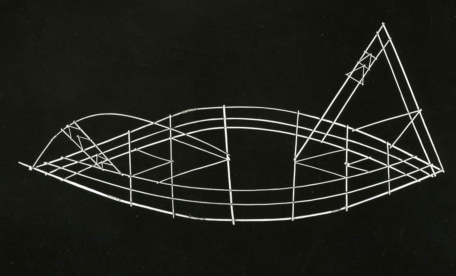
Staff Card
Marshall Islands, before 1898, palm rib, string, and shell
Courtesy of National Museums in Berlin, Ethnological Museum/Martin Franken
Marshall Islands, before 1898, palm rib, string, and shell
Courtesy of National Museums in Berlin, Ethnological Museum/Martin Franken
Westerners observing stick charts for the first time might assume their patterns are as fixed and universal as a map of roads, albeit far more graceful, but the Marshallese stick charts are not charts in our traditional sense. They are accurate—predicting swell that in some cases even advanced Western instrumentation cannot detect—yet they document a form of knowledge that is diametrically opposed. GPS is fixed and universal; the ways of water are fluid and personal.
A rebbelib is highly individualized, the product of a single navigator’s direct perception and lived experience at sea. On all but the glassiest of days, the pattern of waves and swell across the surface of the ocean is absurdly complex, with myriad energetic systems of differing height, width, and velocity moving across one another from multiple opposing directions at once. Captain Brett Hilder, an Australian merchant sea captain and painter, drew attention to this frenetic activity in 1963, stating that on a single day in the mid-Pacific he observed swell coming from at least four different directions, and going on to conclude that it would thus be impossible for anyone to navigate via swell, although of course the reverse is true. Each Marshallese navigator selected the swell he found to be most useful, consistent, and reliable, and while there were multiple generally acknowledged patterns, this selection was inevitably a matter of individual discernment. So it would not be a surprise if different navigators crafted stick charts that included the same island but in relation to different swell patterns. Perhaps as a reflection of their idiosyncrasies, or in part to preserve their secrecy, these charts required the interpretation of their makers to be read.
Because their talents so vastly exceeded ours, it may be tempting to assign them to an almost magical source, but this too would be a misinterpretation. In 1968, the New Zealand–born Dr. David Lewis—a short, sturdy man possessed of an iron will and humble persistence—met with surviving indigenous navigators in the Pacific and sailed with them across hundreds of miles of open sea passage while documenting their methods. An accomplished sailor in his own right, Lewis had previously circumnavigated the globe in a catamaran and sailed the twenty-two hundred miles from New Zealand to Tahiti without using modern instruments, yet his observational abilities were dwarfed by the islanders. Whenever he asked, navigators were quick to reply that they did not have or use a sixth sense. They were the keenest of observers, pointing out to Lewis their observations and deftly directing their vessels through storms even when, with his own eyes on the same seas, he could not follow their acuity.
Holding course by swell was often more a matter of feel than sight. The islanders could navigate at night or under cloudy skies purely from the feel of the sea under their craft. Lying flat on their backs in a plank canoe, they could determine the direction of an island by analyzing the roll and pitch of their vessel as it rode the waves. But they did not rely only on swell. This was one component—albeit crucial—among thousands of ongoing sensory observations as they gauged the stars, sun, wind, birds and aquatic life, the color of the sea and of clouds, and, at times, an underwater phosphorescence unique to the mid-Pacific that has never been scientifically explained.
By the time of Lewis’s visit to the Pacific, this knowledge was dying out. In the eyes of Westerners and most islanders alike, the old sea culture of the Marshallese was of little value when compared to the spectacular achievements of contemporary technology. External tools were replacing direct observation; a dwindling number of navigators had few if any students. Today, it seems only a handful of navigators remain, though a grassroots effort is underway to collect and pass on their knowledge.
Our expanding barrage of technologies may bring dazzling new capabilities, affording us comfort, ease, and safety as we negotiate our paths through the world. Seen another way, however, these tools reveal the blind spots of a landlocked perspective. They encourage us to view ourselves as discrete units in the homogenous grids indexed by our satellites, though this is at best only one side of the story. We are ongoing waves of respiration, peristalsis, pulse, and neural activity. The electromagnetic waves emanating from our hearts are easily measurable several feet away, and our brains generate an oscillatory musical soup that is to this day the most complex signal we have found in the universe. We possess highly specialized organs—eyes, ears, a voice box—to generate and receive the waves with which we communicate, all of it coursing through bodies that are mostly composed of the same stuff as oceans, constantly replenished. We have been immersed in waves as our own sensing instruments since birth; when these waves cease, well, that is how physicians define death. The Marshall Island navigators are a reminder of the heights of wave-reading arts it is possible to achieve, as well as the necessary idiosyncrasy of such knowledge, bound as it is to each individual soul, to be kept alive, tended, and told.
This story appears in our spring 2023 issue, Conjunctions:80, Ways of Water.